When it comes to travelling it isn't just about watching places, exploring and socialising, let's just say when you are travelling it's about FEELING THE PLACE, PEOPLE AND CULTURES.
Highest peak in Shimla with 360-degree views of the lovely himachal. Shali Tibba is a peak that is hard to miss. It towers over the district of Shimla, right behind the.. SHALI TIBBA TREK
Chandrashila Trek is one of the popular trek that can be undertaken round the year, in Garhwal Himalayas except during heavy snowing months of December & January.Chandrashila summit is a rock face above the temple of Tungnath, the highest of all the temples in the Himalayas. It is a short but rigorous hike beyond the temple. The Chandrashila summit affords the most beautiful view of the Nanda Devi, Trishul, Kedar Peak and Chaukhamba peaks.Chopta is one of the most beautiful and picturesque spots in the whole Garhwal. The breathtaking view of the Himalayas is treat for the eyes as well as soul. Chopta is situated on the Gopeshwar – Ukhimath road at a distance of about 40 Kms. from Gopeshwar Chopta is 2900 mts high.Deoriatal Lake has captivating surroundings with forest all around. The mighty Chaukhamba Peak & Neelkanth peaks are reflected in the pristine waters of this lake.
Chandrashilla Trek takes you to the world’s highest Shiva temple situated in Tungnath, at a height of 12074 ft. It is one of the five Panch Kedar temples. The summit of Tungnath is Chandrashila Peak at an altitude of 12877 ft. above the sea level. Trekking from Chopta to Chandrashilla via Tungnath Temple and returning to Chopta is around 10 km. This is an all season trek known for its breathtaking landscapes and dense forests surrounded with excellent views of the peaks.
Chopta- The Switzerland of India:
Chopta is called ‘Mini Switzerland of Uttarakhand’. After reaching there we were fascinated by the beauty around us. It is a small village of very few hotels on the lap of the hill overflowed with pink and red rhododendron, deodar and oak. Roads are open but most of the hotels were deep in snow. Chill air welcomed us. Little unknown violet flowers greeted us. All tiredness vanished. A magical power seemed to fill us with life. The near zero temperature was actually enjoyable. In the afternoon around 2 pm snowfall started and temperatures went down a few more degrees.
The only hotel to offer boarding accommodation was Neelkanth. Though the phone was not working after reaching there one room was arranged for us. Only two dhabas (roadside food stops) were running. The caretaker of one of these two was taking care of Neelkanth as it was not peak season. He was addicted to local herbs. He was so intoxicated that we did not know whether dinner would be prepared. That day we stayed there. People from another dhaba came and prepared food for us.
Trek Facts
Altitude:
3925 meters (13100 ft approx.)
Trail Type:
Easy gradient. Trek can get difficult in winters in soft snow. Chopta to Tungnath is a gradual inclined trek going through a beautiful forest of rhododendron. From Tungnath to Chandrashila is a steep inclined trek. The complete area remain covered by snow till mid April.
Rail head:
Haridwar is the nearest rail head. Chopta is 226km.
Road head:
Delhi to Kund (around 40 km before Gourikund) is 405 km and Kund to Chopta is 31 km by road. Buses are also available from Haridwar and Rishikesh
Base Camp: Chopta
Trek Itinerary:
It is one day trek. Starts in early morning and come back by afternoon. The total distance is about 5 km from Chopta to Chandrashila Top. Tungnath is at 3km trek away from Chopta. 3 – 4 hours to reach the summit.
Best Season:
All season trek. September to November is the best time for great views and no snow. In January-March expect lot of snow fall on the trail. From mid April onwards motarable road to Chopta is cleared from snow. The Tungnath temple remains open from June to late October.
The Chandrashila Trek
It is always good to start trekking early in the morning. We got a bit late and started our journey at around 6.30 am. The trek starts on the west slope of the hill through dense old forest of oak, deodar and rhododendron. The trees were covered with moss and the air has a damp smell.
The initial few meters are a bit steep. The chill air and no direct sun made it more difficult but the beauty of the nature around us made the walk enjoyable. After around 20 minutes we got a view of the famous Himalayan peaks, stunningly highlighted by the rising sun. We stopped here for almost 5 minutes to enjoy the scenic splendor. After another 15 minutes we came upon a small fountain of drinking water. During our descent we saw a high altitude rat drinking water here.
After walking for almost 1 km, we took a small turn and suddenly the forest vanished. Open blue skies overhead, green meadows decorated with pink and red rhododendrons could be seen on the downward slope. From here, the trail becomes more or less bare and being the last week of March continuous slopes of snow made up the trail. Few inches of loose snow is not dangerous but in some places the cemented path was covered by a thin layer of frozen ice. You will lose your control and slip for sure if you try to walk on this. I observed water bubbles under those thin layers of ice like some moving creatures.
From this point, stepping became a matter of concern. After another 1 kilometer there is a resting place made of stone benches and a closed small hut. This may remain open during summer. Almost all took a break here after 2 km of amazing trekking. I was surprised to see that my mobile had full signal and I called up my parents to share the joy. The famous peaks like Chaukhamba, Kedar, Gangotri, Satopanth, Neelkanth and many other peaks were standing side by side in front of us making this a memorable moment.
Throughout the Chandrashila trek trail there are many iron fences providing support to trekkers. At higher altitudes these are like life lines. There was no gap between the snow and the fences and we walked on the snow holding the fence with one hand and balancing using a stick in the other hand. We did not bring professional hiking poles and made use of natural sticks fashioned as a trekking poles.
On the way we saw a drinking water tap. A black dog accompanied us all the way. The last 500 meters before the Tungnath temple was almost a flat walk and then suddenly as we reached the temple area the depth of snow increased and the path became scary. There are many loose patches to trap you in snow 3-4 feet deep. Tracing the footsteps of previous day trekkers is very helpful to find a reliable path to walk on.
There are several hotels surrounding the temple but all are closed as the ice level is as high as the roof . For almost all hotels, one third is exposed on one side which faces the slope and the other side, mainly the back portion, is under snow. Even the door of the temple was under snow which is why the temple remains closed in winter.
Tungnath is one among the Panch Kedar and the highest among the five. Not only that, it is the highest Hindu pilgrimage place in world. The history says that the arm of Lord Shiva was found and worshiped by Arjuna here at Tungnath. Actually this is a story of all the 5 temples of Panch Kedar. After the Mahabharat war, to seek pardon from Lord Shiva for killing their own relatives the Pandavas went to Shiva. Lord Shiva, incensed by their deeds, hid himself by taking the form of a bull and hiding in Guptkashi. He later reappeared at five different places as five different parts of the bull’s body. The Pandavas built temples at those places. These five spots are today’s Panch Kedar.
We took around 3 hours and 30 minutes to reach Tungnath with plenty of breaks and fun on the way. A professional trekker can do it in less than 3 hours. We were not able to find the trail coming from Gopeshwar because of heavy snow.
After taking a break and breakfast we started for Chandrashila. It was very confusing. We tried to find the road but no approachable way was found. A distant slope with footprints indicated the direction. After moving in different directions for a while we noticed a stone paved road few feet beneath us. We walked on the asbestos roof on a hotel and crossed the terrace of another to get to that path.
After a few feet, the path went under heavy snow and the slope was steep and continuous from top to bottom. The distance was not very short. After crossing the stretch there was an U turn and again the slope has to be crossed at a higher altitude. It was scary. Another option was to climb a sharper edge covered with dry grass on wet soil. We opted for the second one.
Without looking back we just kept on climbing and finally reached a flat area. It was hardly 100 meters climbing which shortened the walk by 300-400 meters. We reached the end of the slope of Chandrashila peak and behind us was the
????????????????????????????????????
small valley of Tungnath. We reached here at around 10.40 am.
This is a steep trek of almost 1 kilometer. Maybe in summer some other path will help the trekkers, but now it is completely under thick snow. Loose snow made walking tedious. To reach the top from here we took around 40 minutes. After coming one third of the distance there was a small semi flat region. From there till the top, it was almost a vertical walk. The snow became more loose and slippery as we moved forward. Walking without support is not possible for normal trekkers.
Finally after a zig-zag path we reached our goal – the Chandrashila summit – a semi flat small space. The peak did not have much snow. A complete 360 view amazed us. On one side the Kedar, Chaukhamba and many other famous peaks seem like a stone’s throw distance. Another side offered a layered view of the blue Himalayan mountains. It felt like being in heaven. Dry grass covered few smaller and closer peaks with scattered snow here and there.
A small Ganga temple at Chandrashila summit surprised me. Before going on this trek I went through 2 or 3 trek stories but none mentioned the existence of a temple there in Chandrashila. Though the temple is completely snow free, it is still closed because of accessibility problem. Local people informed us that this Ganga temple opens when the Tungnath temple opens.
After taking a few more photos and making another call home we started trekking back as there was a clear sign of snowfall. The steep slope is easy to cross by sliding on the snow. Walking downwards on snow is tougher than climbing. After sliding down the main part, we had two options: Either to take the long snow path or the steeper one covered with grass. We opted for the snow trail. The experience is difficult to express. We all almost took an oath never to do any snow trek again. However we have long since withdrawn that promise and are planning for another one. Around 12.30 we came back to Tungnath temple.
From Tungnath we took a slope to cut the road. After walking a couple of hours, snowfall started and we were lost in wonderment and almost forgot about our destination. We were lucky to have soft sunshine in the morning and cottony snow in the afternoon. The reverse can be adverse.
The same day we came down to Rudraprayag to have a better and more comfortable stay and to cut down on the next day’s tedious drive. Next day nature gifted us another gorgeous experience of driving through snowfall
Important Information
There is no electricity in Chopta. It is advisable to have your battery charged before hand and carry a spare battery. Good quality shoes and walking sticks are a must for winter treks. If you are not experienced go in a group of at least 4 or hire a guide. Professional guides are available at Chopta & Duggal Bitta. Snow boots can be hired from a shop at Baniya Kund.
The only trek with views of 4 of the tallest mountains in the world
LOCATION: NEPAL-WEST BENGAL BORDER
From Sandakphu you get clear views of Everest, Kanchenjunga, Makalu and Lhotse. No other trek in India gives you that.
Take a close look at the outlines of the mountains in the photograph above. You’ll see a profile of a man’s head on the left and towards the centre, his folded hands on his chest. Locals in India and Nepal call it the “sleeping Buddha”. When they stare at it, they are filled with divinity. As a trekker, you are looking at Kanchenjunga.
Further to the left (see below) are incredible views of Everest, Makalu and Lhotse. It is no wonder that the Sandakphu trek is the holy grail of Indian trekking. It does not matter how easy or difficult the Sandakphu trek is, the trek just has to be done.
Trek Itinerary
Day 1: Arrival day ( Base camp – Jaubhari)
Arrive at Bagdogra airport or NJP railway station in the morning (on your own).
Indiahikes will arrange for pick up vehicles/shared cabs from the aiport/railway station to the base camp – Jaubhari.
The cost of transportation to the base camp will have to be borne by the trekkers (to be shared).
It will take approximately 5 hours to reach Jaubhari from the airport/railway station.
Reporting time at Jaubhari is 5 pm, sharp. The trek starts at 8:30am the following morning.
Day 2: Jaubhari to Tonglu
Start trek at 8:30 am from Jaubhari to Tonglu.
You will need to cover a total of 11 km with an altitude gain of 953 m in 7 hours today.
The trail is a combination of gradual as well as steep ascents. There are a few rocky paths, and level meadow walks.
Look out for Chimal and Magnolia trees. If you are lucky and very quiet you might be able to spot a red panda.
You will pass through Lamaydhura – a small Tibetian village, an SSB check post and a buddhist monastery. Foreigners need to keep their visas and Indians need to keep their ID proofs ready for verification at the SSB post.
The trek ends at Tonglu. Camp for the night at Tonglu.
Day 3: Tonglu to Kalipokhri
Wake up early morning to view an amazing sunrise above the peaks of the Kanchendzonga range.
Today’s trek covers a distance of 11 km starting from Tonglu with an altitude gain of 83 m.
The trail goes through forests, a clearing, few meadows and the Singalila National Park.
Watch out for a border stone near Garibas. You will see India on your left and Nepal on your right.
The trail from Kaikhatta to Kalipokhri is perfect for bird watching.
The final destination of the day is a small black lake known as Kalipokhri. You will find Buddhist prayer flags hanging above it.
Camp overnight at Kalipokhri, which is exactly on the India-Nepal border.
Day 4: Kalipokhri to Sandakphu
Today’s trek is relatively easy, mostly level walks with some gradual ascents and a few steep ones.
It is a 6 km trek from Kalipokhri to Sandakphu with an ascent of 466 m.
It will take you approximately 3 hours to reach Sandakphu.
Watch out for Bikheybhanjang (Valley of Poison) en route. It gets its name from a poisonous aconite plant which grows in abundance here.
You will trek through forests of silver firs, rhododendrons, magnolias and lovely large-leaved drumstick primulas.
Enjoy a 180-degree panoramic view of the Himalayan peaks from here.
You will be able to see Makalu, Lhotse, Everest, Nuptse, Baruntse, Chamling, Chomolonzo, Machapucchare and other peaks of the Annapurna range spread on towards the west. Three sister peaks stand tall towards the north and then of course, the Sleeping Buddha lies before you.Towards the east, you see the highest ranges of Bhutan – Chomolhari which rises above of all other peaks around it.
Mobile network is available at the highest point in Sandakphu.
The temperature at the top dips to sub-zero post sunset.
Day 5: Sandakphu to Phalut
Start trekking early morning from Sandakphu. You will need to descend down to reach Phalut.
It’s a long trek covering 21 km in approximately 8 hours.
Look out for the Forest Check Post at Sabarkum en route.
After descending 21 km (37 m) you will reach Phalut.
Camp for the night at Phalut.
Day 6: Phalut to Gorkhey
The trail is mostly descending with a few gradual ascends between dense forest cover.
It covers a distance of 14-15 km starting at Phalut and ending at Gorkhey.
It will take you around 3 hours to reach Gorkhey.
The highlight of today’s trek is the river crossing (Gorkhey river) at the end of the day.
Camp overnight at Gorkhey.
Day 7: Gorkhey to Sepi
Depart from Gorkhey to Sepi early morning.
You will reach Sepi around 1 pm. The trek ends at Sepi.
Other Important Information:
Altitude: 3636 m, Sandakphu
Difficulty: Moderate
Trail type: Mix sections of gradual and steep ascents going through Singhalia National park, which involves trekking through forest cover and meadows. The trail can become difficult during monsoon.
Rail: NJP is the nearest rail transport to JAubhari.
Road: Buses and cabs are available from NJP to Darjeeling.
Nearest Airport: Bagdogra Airport, Siliguri, West Bengal
Base Camp: Jaubhari
Note:
Total Distance: 77 km(entire trek)
Accommodation: The Sandakphu trek is a tea-house trek, wherein you’ll be staying at tea houses / lodges. You will not be camping in tents. You’ll be sharing rooms with your trek mates on all days.
Guides and Porters: Guides and Porters can be hired from Maneybhanjan, Jaubhari or Darjeeling. Ponies are not allowed on this trek.
Weather: Temperatures can drop between 0-5 degree celcius at night. The temperature during the day remains pleasant. Expect extremely windy conditions and sporadic rains.
Permits: You will need a permit to enter Singhalila National Park. It can be obtained while you are on the trek.
Upon arrival at Hangzhou, check into an economical hotel. After setting down at the hotel, hire a bicycle and cycle around the West Lake. Take time to appreciate the ten classical sites around the lake, such as Su, Bai causeways, broken bridge etc.
On your second day, expore places like Laohe Hill, Qingting Hill, Jiangjun Hill, Beauty Peak, Baiyun Peak, Jiuhua Mountain. Laohe Hill is located near the Yuquan campus of Zhejiang University and can be reached by taking one of these buses: No. K293, 82, K82, K89, K16, 21, K21, K101, 15, K15, 815, 527, or K527. Alight at the Yuquan campus bus stop. Distinctive signs are posted along the way, so you won't get lost. The whole journey will take about 6-9 hours.
Take a city tour on your last day in Hangzhou.
Hangzhou04 : 2 Days Hangzhou - Changhua - Western Grand Canyon - Longgang - Daming Mountain - Hangzhou
If you do not have your own transport, take a coach at the West Coach Station. The coach runs frequently at several minutes interval. It takes about 2½ hour to reach Changhua town from Hangzhou and the fare costs CNY15.00 per person.
Upon arrival in Changhua, take another bus to the Western Grand Canyon. The fare is CNY5.00 and the journey takes another 1½ hour. Visit Tuolin Waterfall, Jianmen Pass and Laojiao Stream. Since the places of interests are far apart, it would be more convenient to travel in a group with others in a chartered van. This way, you can have the driver to drive you to the entrance and pick everyone up again at the exit and then transfer to the next site. It takes about 40 minutes' drive from Changhua to Longgang.
Stay overnight at a local clean hotel.
Head for Daming Mountain the next day. It is a majestic and splendid site but takes about 7 hours' to hike up the mountain on foot. You will appreciate all the natural wonders as you climb up the hill. It is a good idea to start hiking early, preferably before 10:00AM. Pack some high energy foods, like roast duck, chicken, ham and sausages that provide and maintain strength. Call 0571-63709588 for more information.
There is no direct transport services between Daming Mountain and Hangzhou, so you need to return to Changhua first and then take the coach back to Hangzhou. Time is a little bit tight if you return to Hangzhou in one day, so make the best of your time.
Hangzhou05 : 3 Days Hangzhou - Bao'an - Longjing Village - Longxi Village - 28 Du - Jiangshan - Hangzhou
Bao'an town, a Jiangshan city of Zhejiang province, is the gateway to Xianxia Old Trail. It is 240 kilometers away from Hangzhou and will take 4 hours' drive.
After a good rest in Hangzhou city, take a coach at the South Coach Station on Qiutao road to reach Jiangshan city on the first day. The coach runs every hour from 07:30 hours to 18:00 hours daily. Upon arrival at Jiangshan, find a hotel for a good rest for the night.
On the second day, take a bus from Jiangshan to Bao'an at the new bus station. It is about 52 kilometers from Jiangshan to Bao'an and the journey will take 1 hour 40 minutes. Xianxia Old Trail is one of the most complete preservations of the Huangchao uprising and hiking will commence from this point.
There are in total 4 stone passes. Hike to the First and Second Pass; visit Longjing and Longxi villages. It is also worthwhile going up the hill along the path and cross Xiaoganling to reach an old town called 28 Du. Its special location and the frequent wars made the town a clustering of dialects. As a matter of fact, there are in total 9 different dialects and more than 130 surnames. The town maintains the ancient architecture and life style. Enjoy the local flavors and stay at a local hotel.
On the following day, hike for 45 minutes and you will reach Fengling Pass, which looks like a bridge. Visit Fugai Rock and return to Hangzhou via Jiangshan.
Hangzhou06 :3 Days Hangzhou - Putuo Mountain - Shenjiamen - Peach Island - Hangzhou
If hiking Putuo Mountain is to your fancy, take a bus from Hangzhou to Shenjiamen at the Hangzhou East Coach Station. Call 0571-86964011 for more bus information.
There are 8 scheduled buses running from Hangzhou to Banshengdong port at Shenjiamen from the coach station and the journey will take about 4½ hours.
There are hourly ferry services to Putuo Mountain which takes only half an hour. Speed boat services are also available and takes only about 10 minutes. Call 0580-6091124 for further information.
Hike to Xitian Scenic Area, including Kwan-yin Ancient Cave, Pantuo Rock, Xinzi Rock and Puji Temple.
On the next day, continue visiting Nantian Gate, Purple Bamboo Forest and Nanhai Kwan-yin in the morning. Transfer back to Shejiamen by speed boat. Upon arrival, enjoy the night scenery of the fishing harbor.
It is a good idea to visit Peach Island on the last day. There are both ferry and speed boat services between Shenjiamen and Peach Island. It takes only 20 minutes by speed boat to reach Peace Island. It is better to purchase a return ticket beforehand. Please remember that the last ferry and the speed boat services is at 17:00 hour and 15:00 hour respectively.
Visit the Shediao Entertainment Center, Dafo Rock Scenic Area and Peach Valley Scenic Area. Return to Shenjiamen and take a coach back to Hangzhou. Your pleasant hiking tour ends here.
Trekking in Other Destinations of Zhejiang: Jinhua, Lin'an, Ninghai, Shaoxing, Wenzhou
Other Important Information:
Chinese: 西湖 Xī Hú /sshee hoo/ (xi is 'west'; hu is 'lake')
Location: Southwest of downtown Hangzhou, 180 km southwest of Shanghai
Area: 6.5 square kilometers (2½ square miles)
Highlights: The Ten Scenic Sites of West Lake, boat cruises, biking, scenic walks, Impression West Lake night show
Recommended visit: 2 days
West Lake was selected as one of the "12 superb sunset spots around the world" by CNN. Walking around West Lake is free, so amble around al leisure to appreciate the beautiful scenery. The best places to photograph sunset views are Broken Bridge, Su Causeway, and Yanggong Causeway.
Highlights You Shouldn't Miss
Su Causeway and Bai Causeway — best in spring
Lotus in the Breeze at Crooked Courtyard, one of the ten scenes of West Lake
Su Causeway features in one of the best-known "Ten West Lake Sights". It is a long causeway with willows and other plants on both sides.
Viewing Fish and Lotus Fronds at Flower Pond
At the southern end of Su Causeway, it has been made into a charming park with many varieties of trees and flowers, featuring a peony garden which blooms in April, and the famous goldfish pond.
There are ten famous scenes of West Lake. Every scene has its own iconic features. Read more about other highlights of West Lake.
Impression West Lake — the night show on the lake
Impression West Lake is an outdoor live performance. Performed in the evening, with lights, music, and dancing on its West Lake stage, it tells a beautiful love story of five acts: "Encounter", "Fall in Love", "Say Goodbye", "Memory", and "Impression". The show is available from March to December.
Tickets: 250 yuan (40 USD) – 600 yuan (100 USD)
Best times: spring and fall
April to October: 7:45–8:45
March, November, December: 7:15–8:15
If the weather is good and demand is high, there may be a second performance from 9:45 to 10:45.
Music Fountain Show
There is a music fountain at Lakeside Third Park Dock, West Lake. The fountain area is 126 meters long, erupting into life twice in the day and four times in the early evening.
Lasting: 15 minutes in daytime, 10 minutes at night
How to Get to West Lake
Hangzhou Xiaoshan Airport – West Lake: about 30 km
Our guide introduce guest about West Lake on the way.
Book private transport (recommended): We advise you to book a transfer service with a driver and travel guide. So that you don't have to worry about getting lost and can learn about West Lake on your way to the site.
Take a taxi by yourself (less recommended): If you don't want to book a transfer service or tour, you can take a taxi from the airport. It's about 1 hour's drive. Most drivers don't speak English, so you may should prepare the name of where you want to go on West Lake in Chinese.
Take airport bus (not recommended): If you want to save money and can use a Hangzhou bus map, you can take the airport bus. It's about 2 hours' drive, including the bus waiting time. First take the airport bus to Hangzhou Railway Station, and then take bus Y2 to Jingsi (净寺).
Is it possible to have a one day trip to West Lake from Shanghai?
The answer is YES! Travelling between Hangzhou, Suzhou, and Shanghai now is very convenient because of the bullet train system. You can travel from one to another in about 1 hour.
Nearby Attractions
Lingyin Temple
Lingyin Temple: 'Temple of the Soul's Retreat' is a quiet and sheltered sanctuary. It is one of the largest and most-visited Buddhist temples in China, and holds the largest statue of the Buddha Sakyamuni in the lotus position.
Qinghefang Pedestrian Street: The shops are mainly oriented for tourists, and they sell curios, paintings, souvenirs, craft products, and other works of art. There are also restaurants featuring foreign food for tourists, and some teahouses and shops with long histories.
Six Harmonies Pagoda: It offers a fine view of Qiantang River, famous for the world's largest tidal bores, which are extremely spectacular during the Mid-Autumn Festival.
Meijiawu Tea Plantation: It is one of the Four Famous Sites for Longjing Tea (Dragon Well — "China's Top Tea"), featuring a tea farm and village with rich tea culture and tourist development. It attracts over a million tourists every year.


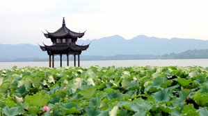 Lotus in the Breeze at Crooked Courtyard, one of the ten scenes of West Lake
 Our guide introduce guest about West Lake on the way.
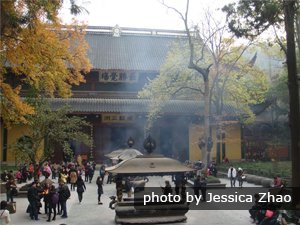 Lingyin Temple